
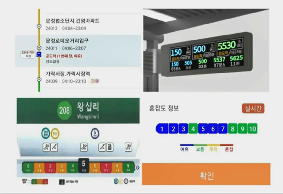
The Seoul Metropolitan Government has started providing real-time congestion information for vehicles such as buses and subways to enhance the convenience of citizens.
In the case of buses, real-time arrival and vehicle congestion information are provided by the bus BIT. The level of congestion in the bus is guided to three stages: △ spacious, △ normal, and △ congestion.
The bus congestion degree is calculated by the number of people getting on and off from the traffic card terminal. ▲" spacious" means the status in which a standing passenger can sit, ▲and "Normal" means the status in which standing passengers can stand holding a handle, and ▲"Congestion" means that there are passengers in the aisle between standing passengers.
When searching bus information in a map application, the congestion level is also indicated, so it is helpful to find out in advance before boarding and choosing a vehicle with enough space.
The subway provides congestion information on lines 1 to 8 in four stages: △ "light," △ "Normal," △ "Caution," and △ "Chaos." Since the information is provided in detail, if there are many passengers in the subway, passengers can move to a spacious compartment to use the subway more conveniently.
▲"Spacious" and "Normal" stages indicate the status that it is possible to move freely, ▲"Caution" refers to the degree that passengers can be bumped into each other when moving, and ▲" Chaos" refers to a situation that it is difficult to move to another compartment.
Congestion levels of lines 1 to 8 are measured in various ways, such as traffic card information and weight sensors for the number of passengers on vehicles, to increase accuracy.
In order to help passengers understand the congestion level at a glance when using the subway, the congestion levels for each compartment of lines 1 to 8 in the metropolitan area are presented through the "Ttota Subway" app.
In the case of the "Ttota Subway" app, real-time train information is provided, and vehicle temperature control requests can be easily made through location information. It provides various services necessary for using the subway, such as convenience facilities such as bicycle slopes and information on getting on and off electric wheelchairs.
Baek Ho, head of the Seoul Metropolitan Government's Urban Transportation Office, said, "If you check various traffic information in Seoul, you will be able to move more conveniently," adding, "To prevent the spread of COVID-19, we ask you to comply with personal quarantine rules when using public transportation.”
Reported by Smart City Today


![[토큰경제학] 엔비디아의 다음 돈줄은 GPU가 아니라 메모리다](https://cdn.www.smarttoday.co.kr/w400/q85/article-images/2026-06-10/b8779f99-0e61-4370-ab4d-d84e450ee10e.jpg)
댓글 (0)
댓글 작성
댓글을 작성하려면 로그인이 필요합니다.
로그인하기