
The Ministry of Land, Infrastructure and Transport announced that it has developed a standard analysis model for spatial big data to make it be used easily and conveniently. The government released it through the "Space Big Data Analysis Platform" on December 31.
The spatial big data standard analysis model is a model that standardizes the format and analysis procedures of data for use in various policy decisions based on spatial information and has the advantage of △reducing costs and △making data-based scientific decisions.
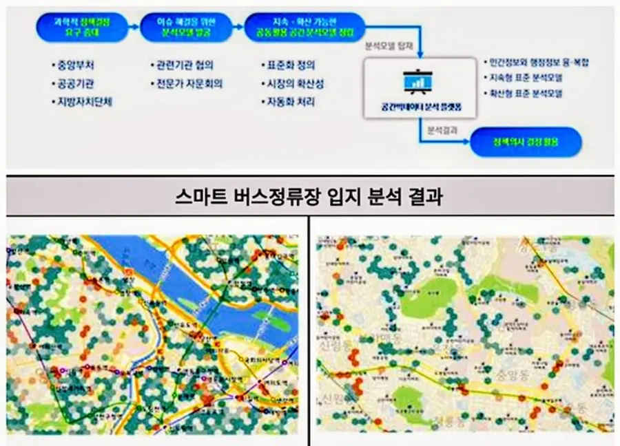
For example, the standard analysis model of the "Smart Bus Station Installation Location Analysis", which was developed for Seoul, can be used in Gyeonggi-do by entering data according to the data format and can be easily used for the analysis of vulnerable areas in libraries and areas lacking COVID-19 screening clinics.
This year, five types of public administration and policy tasks such as bus stop loophole area analysis and fire-vulnerable area analysis were developed, and based on data that Seoul Metropolitan Government and others are using for actual work, they actively reflected opinions of demand organizations, and implemented to help solve current issues and establish policies in each region.
The standard analysis model of space big data released this time is △ the analysis of bus stop loophole area (Seoul City), analysis of installation location of the smart bus stop (Seoul City), analysis of the vulnerable area of fire (Dongjak-gu, Seoul City), analysis of the vulnerable area of child care (Dongjak-gu, Seoul City), analysis of unauthorized dumping and multiple areas (Gangseo-gu, Seoul City).
The following are examples of the standard analysis model developed this year.
△Analysis of bus stops and routes (Seoul City)
It is a model that analyzes bus stops or bus route loophole areas compared to user demand by combining bus stop location and regional total population data and can be used for public transportation policy establishment and adjustment.
△Analysis of fire-prone areas (Dongjak-gu, Seoul)
It is a model that analyzes areas where fire response is difficult within Golden Time using fire occurrence, location of the fire station, and road information data and can be used to add fire safety facilities and install fire prevention centers.
△Analysis of the Location of Smart Bus Stations (Seoul City)
△Analysis of Child Care Vulnerable Areas (Dongjak-gu, Seoul)
△Analysis of the habitual and multi-volume areas of unauthorized garbage dumping (Gangseo-gu, Seoul)
The standard analysis model was developed using the "space big data analysis platform" with advanced analysis speed and function, and anyone can easily read and use it on the Internet.
In addition, it is possible to analyze and develop spatial information as desired by the user based on the platform, and it is also possible to provide services such as requesting analysis and applying for education.
“Spatial big data analysis and utilization technology not only supports rational policy and decision making but also is an indispensable technology in the era of the Fourth Industrial Revolution,” said Kang Ju-yeop, director of the Ministry of Land, Infrastructure and Transport. “We will continue to develop and utilize diverse and creative standard analysis models to contribute not only to fostering the spatial information industry but also to improving the lives of the people.”
Reported by Smart City Today


![[토큰경제학] 엔비디아의 다음 돈줄은 GPU가 아니라 메모리다](https://cdn.www.smarttoday.co.kr/w400/q85/article-images/2026-06-10/b8779f99-0e61-4370-ab4d-d84e450ee10e.jpg)

댓글 (0)
댓글 작성
댓글을 작성하려면 로그인이 필요합니다.
로그인하기